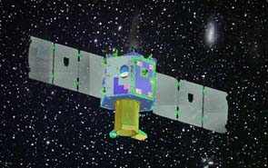
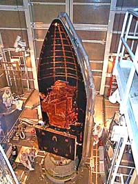
By the end of the decade a revolutionary new micro-satellite will orbit around the world at an altitude of 700km sending precise information on agriculture and marine changes in unprecedented precision and detail. The Israeli-French project will allow farmers to better treat their crops, fisherman to locate large quantities of fish in mid-sea and will also vastly increase the ability of the scientific community to study and monitor the flora and fauna in many areas around the globe. Equipped with an advanced plasma engine, VENUS will be able to operate for at least 4-5 years in its planed orbit.
Modern satellites have many applications. Beside the obvious military uses satellites today are used for communication, navigation, space research, weather prediction and earth observation. This last type of satellites has many important functions. They conduct environmental monitoring, help create and improve maps and play an important role in the development of agriculture and fishing.
The heart of most observation satellites consists of a camera. Early satellites carried panchromatic cameras capable of taking pictures in only one spectral “band”. Pictures originated from a panchromatic camera are usually displayed in grey scale, where the brightness of a particular pixel is proportional to the intensity of solar radiation reflected by the target. Even today many reconnaissance satellites still use panchromatic cameras which are considered to have the highest resolution of any space-based camera type. A more recent development is the multi-spectral camera which can create color pictures that consist of a number of image layers; each layer represents an image acquired at a particular wavelength band. For example, the French SPOT 5 sensor operating in the multi-spectral mode detects radiations in four wavelength bands: the green (500-590 nm), red (610-680 nm), near infrared (790-890 nm) and the short-wave infrared or SWIR (1580-1750 nm).
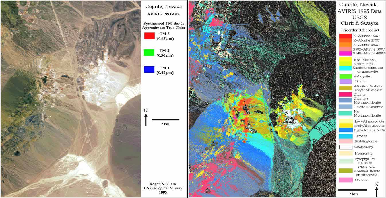
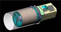
In order to improve the capabilities of space-based cameras even further, super-spectral cameras with 10 bands or more were developed in recent years capable of receiving and analyzing a wider range of information. For instance, using a super-spectral camera it is possible to examine whether trees in a specific part of a forest are dry, or whether a portion of the sea contains a large amount of chlorophyll. There are currently only a handful of super-spectral cameras in orbit around the world and the one planed for the new VENUS project is going to have some unique features that have been explained to IsraCast by Eytan Reis, Director of Marketing & Business Development for the space program in the Israeli company EL-OP which developed the VENUS’s camera. Besides its relatively high resolution – 5.3m across all of its 12 bands – it was specifically fine-tuned for its purpose of analyzing agriculture and water quality. The direction the industry is taking these days is to expand the number of bands, and there are already a few hyper-spectral cameras in orbit capable of analyzing hundreds of bands at a time. EL-OP is also working in this direction, said Reis, but today most hyper-spectral cameras are still complicated, expensive and have fairly low resolution. The super-spectral camera selected for VENUS is therefore the perfect choice for the project, giving high resolution on one hand and a wide range of specially selected bands on the other.
The 40 years of heavenly observations
This year the human endeavor to observe and record the multitude of changing aspects of our planet has reached its fortieth year. In 1966 the U.S. government has initiated the Landsat program (originally called the Earth Resources Observation Satellites Program). The aim of the program was to create a unique resource of information on global change research and applications in agriculture, geology, and forestry that will help regional planning scientific research and education. Since the launch of the first Landsat satellite in 1972, millions of pictures were taken by the various Landsat satellites which transformed the way we look at our planet. Since then other countries have also developed similar space programs. One of the most successful was the French SPOT (Satellite Pour l’Observation de la Terre) series of satellites launched by the French Space Agency (CNES) since 1986.
The birth of VENUS
The roots of the VENUS project date back to 1994 when the Israeli Space Agency (ISA) and the French CNES established space cooperation. In 1997, the two agencies envisioned working together on micro-satellites. It took another six years but in December 2003, the objectives of the VENUS (or Vegetation and Environment Monitoring New Micro-Satellite) mission were defined and the project was officially underway. VENUS’s primary mission has been defined as a multi-spectral observation satellite for the European Global Monitoring for Environment and Security program (GMES). CNES officially stated four of the main goals of the VENUS mission:
- Enable significant advances in understanding and modeling of continental land surfaces, by combining space-based and in situ observations with vegetation and soil models.
- Promote research procedures of monitoring water quality in the coastal plain and inland water bodies.
- Help to improve how terrestrial surfaces are represented in meteorology, climate, and carbon models.
- Demonstrate the value of this kind of observation for sustainable land management, decision support, and environmental monitoring.
In an interview with Dr. Zvi Kaplan, the director of the Israeli space agency, IsraCast was told that the VENUS satellite, using its super-spectral camera, will enable farmers to view their fields with high resolution (5.3m) and using the data received from the analysis of the camera’s various spectral bands to decide how much nitrogen, water and fertilizer every part of their field requires. This could lead, in the future, to a fuller implementation of the idea of Precision Agriculture in which farmers use data from GPS satellites as well as from observation satellites in order to improve their crops. Since the VENUS satellite will orbit the earth in a 500-700km polar orbit (which will permit the vehicle to receive continuous sunlight and hence power during its entire mission) passing over every point around the globe every 48 hours, it can become an ideal tool for monitoring changes in vegetation for farmers and scientist alike.
VENUS in the sky with ions
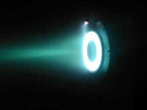
Two other aspects of the satellite which are also worth mentioning are the engine and the over all size and weight of the system. After being denied access to advance space technologies for many years, Israel developed its own unique space infrastructure. Joining only a handful of other countries that possess the ability to build, launch and maintain their own satellites, Israel has become a leader in building sophisticated small, lightweight satellites. These micro satellites can achieve today what some multimillion dollar satellites could only dream of a few years back and with a fraction of the cost. One important aspect of this revolution is the propulsion system, a field in which the Israeli RAFAEL Armament Development Authority has grown to become a world leader. Although people might think that satellites do not need a propulsion system orbiting the earth at a constant altitude, the reality is very different. Low Earth Orbit (LEO) satellites (like the VENUS) are exposed to some extreme “weather effects” in space. The biggest space weather effect to LEO satellites is the atmosphere of Earth itself, and the way it inflates during solar storm events. This causes high-drag conditions that lower the satellite orbit by tens of miles at a time. To prevent premature orbital degradation as well as to be able to perform other planned and unplanned trajectory changes, satellites are equipped with a special propulsion system. The most common satellite propulsion system is chemical propulsion which uses rocket fuel such as Hydrazine. One of the problems with using chemical propulsion in lightweight satellites is the need to allocate a large portion of the satellite mass for the propellant. To overcome this problem engineers have been working for the last several decades on electric propulsion system that will use beams of ions for propulsion. Along the years, several types of electric thrusters have been developed, one such type is the Hall Effect thruster. Hall thrusters were studied independently in the US and the Soviet Union since the 1950’s but until recently were not used extensively in the West. The Hall Effect thruster works by accelerating a propellant (such as xenon gas) in a magnetic field. Hall Effect thrusters use the Hall Effect (basically a potential difference) to trap electrons and then use them to ionize the propellant, accelerating the ions to produce thrust, and (unlike other types of ion engines) neutralize the ions in the plume. Hall Effect engines are considered to be highly efficient, and while standard chemical rocket engines thrust their propellant at speeds of around 1700m/s, Hall Effect engines can thrust almost ten times as fast reaching fuel efficiency of 60%, much higher than any chemical engine. Using its high efficient Hall Effect thrusters, VENUS will be able to perform its task without carrying a large amount of fuel and will continue to operate for at least 4-5 years in its planned orbit.
Special thanks to Tal Inbar, senior research fellow at the Fisher Institute for Air and Space Strategic Studies, who assisted creating this article.